Local
historian, Andrew Lamberton, has written a booklet called "Reaseheath, a short
history".
This booklet is now out of print, but he has kindly agreed to allowed me to reproduce parts of it on the web.
Introduction

Aerial view of Reaseheath Hall 1958 showing the new machinery shed and hostel buildings.
In the top right hand corner can just be seen a faint outline of the mediaeval earthwork.
It is unusual for visitors arriving at Reaseheath not to be impressed with the charming elegance of the Hall and the surrounding Estate in which it stands. Questions are inevitably asked about the history of this Estate and until recently, little information has been freely available to assist the enquirers. This booklet has been written to satisfy that need.
I am indebted to J. Hall's "History of the Town and Parish of Nantwich".
I also wish to thank John Wilson, Simon Young and the Rev. D.A. Martin, T .D., Vicar of Acton Church, for their assistance. Permission to publish details from the Richard Wilbraham Will, the Tithe Map and 1919 Estate Map has been obtained from Mr B. Redwood, County Archivist, Cheshire Record Office.
|
|
A balloon goes up at the cottage hospital garden party, Reaseheath 1913 |
WHAT'S IN A NAME?
One can assume that Rees heath or Rease heath was originally a heath, common or wasteland. It would probably be covered with low growing shrubs, gorse, heather and some trees. The word Rease most likely comes from the word to rease or raise, hence 'raised heath'. The word is used several times in the Malbon manuscript of Thomas Malbon, Lawyer, Nantwich, who left a detailed account of the Civil War in Cheshire and adjacent Counties dated 1651 (as recorded in J Hall's ‘History of the Town and Parish of Nantwich').
1. "The Commissioners of Arraye, viz., Earle Ryvers; and his brother, Mr. Thomas Savage; Lord Viscounte Kilmorey; Lord Cholmondeley; and the rest which weire fledd to Chester, Reased (raised) all theire force together to Chester with many Horse and foote from all theire frends and tenants in Shropshire, Cheshire, and Wales, with many threatnyng speeches to dryve theim awaye from Namptwiche".
2. "On Thursday (sic for Wednesday) the xx4th of January 1643(4), the Ryver was Reesed soe heighe that theire platt* was carryed downe, and they by noe meanes cold passe the Reever, the on(e) to the other".
* temporary wooden bridge, probably a raft or pontoon.
3. "Upon the nexte Saturdaye after the Seige was reased (ended) theire was a greate markett in Towne began agayne."
4. "The names and nu'ber of prisoners of note, taken att Reasing the Seige, as appeared by a Liste, weire ....... etc."
It will be noticed that both spellings are used in the MS and as Reaseheath is referred to under either spelling in various maps and documents, this would lend further weight to the origins of its name.
Stella Davies in her book ‘Agriculture in Cheshire 1750-1 850’ suggests that Rees Heath was an extension of Beam Heath with the River Weaver separating the one from the other.
Beam Heath refers to the heath or wasteland at the Northern extremity of the town boundary. Beam is saxon for tree. This was a portion of land that was granted to "the whole commonalty of the vill of Wich-Malbanc" by the Lords of Alvaston on the tenth day of April 1285. This land, together with many surrounding townships formed part of the Barony held by the Norman family of Malbank. On the death of William Malbank, Third Baron of Wich-Malbanc, the lands passed to three daugh ters, one receiving the township of Alvaston. We still remember the Norman peers by the name given to the fields and roadway running at right angles to Beam Street i.e. the Barony.
Details of the original deeds relating to the granting of common rights for Nantwich townspeople can be found in J. Hall’s ‘History of the Town and Parish of Nantwich’.
In 1779 and 1780, a Work House was erected on the Barony on 111/2 acres of land given by the Marquis of Cholmondeley. On 3rd April 1881, the population of the Work House was 142 males and 80 females.
The Barony Hospital now occupies the site of the Workhouse.
Horse races were run for many years on a course in Alvaston until 1824 when the land was enclosed and cultivated.
Upon examining old and modern maps, it would appear that Reaseheath village is concentrated to the North West of the Estate. What we know as the Green and the cluster of cottages in its immediate vicinity may have originally been called Beambridge.
‘Cheshire Field Names’ refers to Beam bridge as follows - a bridge made of a beam or beams, may have been a single beam. Gives name to the hamlet in Worleston.
References to Beambridge in J. Hall’s ‘History of the Town and Parish of Nantwich’ are as follows
1. Malbon M.S. (see earlier)
a) "The Enemy dispersed theim selves into the fields and down Henhull Lane to Beambridge, contynvallie shootinge att the Towne with their musketts to small purpose;"
b) "Yett ytt pleased God, upon thawinge of a great Snowe, (which then was) That the Reever Weever began to Ryse, and the King's partie being afrayde that the water wold take down a platt they made for theire passage over the Reever, a little below Beambridge for theire free passage to releeve one the other, (for Beame-bridge being a fayre Stonne Bridge, almost but newely made, was a greate pte. of ytt beaten down;) On the xiiij of January 1643(4), thev conveyed over the Reever all theire Ordnance and Carryages, and moste pte. of theire horse and ffoote towards Acton Churche".
2. Roger Wilbraham's M.S.
‘Included in 6 long paragraphs (abbreviated) as instances of God's Judgement during 16 years "who being overwicked, came to an untimely end".
"Cicely Eaton, hearing of a Christening at Beambridge, thither she went and having got more drink to her share than she could carry home, sett her down upon ye Battlements of the Bridge and fell backwards into ye River". (Buried 5th October 1694).
3. ‘An amusing incident in connection with a soldier's wedding at Nantwich is thus told in the Chester "Chronicle", dated Friday, December 7th, 1804’.
"Monday last (Dec. 3) at Nantwich, Mr. Scholfield, sergeant of the Army of Reserve, to Miss Betty Hallwood (?Hollowood)* of Beam Bridge. This marriage being against the consent of the lady’s friends, the brother of the bride actually stript to fight the parson in the church for marrying them, who was obliged to procure constables to keep the peace during the nuptial ceremony; after which the bride was borne off in triumph by the bridegroom under one arm, and a corporal of the same regimen t under the other, to the no small gratification of a large concourse of spectators".
* The Tithe Map of 1842 confirms that Stephen Hollowood lived near the Green.
4. ‘Church Registers - Baptisms - June 7th 1780. An illegitimate child Baptized at Beam Bridge, John’.
George Ormerod, in his 'History of the County Palatine and City of Chester' records that ? Windsor of Beambridge married Alexander Elcocke of Whitepoole (circa 1700).
Rease meadow is referred to in Richard Church’s Will dated 21st June 1592 (from
J. Hall’s ‘History of the Town and Parish of Nantwich’).
"The property in the co. of Chester and elsewhere to my son William Church, also his howse in Hightowne, also Birchin Lane Croft in Wigterson (Willaston) also Rease Meadow in Worleston."
If the 1842 Tithe Map is referred to, it will be noticed that all the meadows except one, border the River Weaver. We can therefore assume that one of these is referred to in the above will, and it could possibly be one of those which are simply referred to as - meadow.
Sites of Antiquity
One can only conjecture on the likelihood of an early settlement at Reaseheath, but archaeological evidence gives pointer to occupation or at least some form of habitation in the vicinity, during and after the Roman occupation of Britain.
It is known that Roman remains were found on the Estate when it was bought by the Cheshire County Council and being converted into use as a School of Agriculture (see Map)
In ‘Roman Cheshire’ by F.M. Thompson, the following is recorded-
"In 1920, a stamped tile of the Twentieth Legion, and pottery of types manufactured at Holt were found at Reaseheath Hall. . . . . . . and if the discovery can be regarded as genuine, it points to the existence of a site in the area".
The existence of a Roman road (see Map) has been confirmed fairly recently from aerial surveys and detailed field reconnaisance. This road may well have connected Northwards to the Middlewich to Woolstanwood section shown on modern O.S. maps and continuing, South-West into the parish of Henhull and on to Baddiley lodge and Wrenbury.

The mediaeval earthwork (see Map) consists of a wide ditch on three sides of a rectangle. This shows up clearly on aerial photographs. The origin of these earthworks appears to havc been in the 14th or early 15th Century and it is thought that they may possibly enclose a building and therefore be of a defensive nature. If no trace or building is evident, then it may be that it was used purely as an enclosure for stock or possibly as a status symbol.
Reaseheath in Tudor Times and Beyond
The earliest reference to Reaseheath is taken from George Ormerod’s "The History of the County Palatine and the City of Chester" where he records that Roger Chetwod of Worlaston and Ralph Wilberham bought land in Worleston as joint tenants from Richard Cleyton of Henhull in 1538
The 1580 Visitation of Cheshire records that Thomas Chetwood, his son Roger and his grandson James all lived at Rees, but James evidently left Rees and went to live in Staffordshire before 1583.
In the same Visitation is recorded Richard Wilbraham of Rees, freeholder. The Wilbraham family has long been associated with Nantwich and the surrounding area. The earliest known ancestor was Richard de Wilburham who was Sherrif of Cheshire in 1269. The family name may have originated from the manor of Wilbraham in Cambridgeshirc, but this particular family branch is traced back to Radnor in Cheshire. Radnor is a small township in the parish of Astbury (between Sandbach and Congleton).

Extract from the will of Richard Wilbraham of Worldston (Reesheath) 1624
"In the name of God amen I Richard Wilbraham of Worldston Gent……..my last will and testament as followeth. First I doe bequeathe my ………….
Information in connection with the Wilbrahams and Reaseheath is scanty. It is known from the 1663 Visitation that William and his son Thomas Wilbraham were living at Rees then.
It appears that the Windsor family (through marriage in the female Wilbraham line) lived at Reaseheath from at least 1716 up to 1772 when it was sold to Henry Tomkinson of Dorfold Hall.
The Tomkinsons of Reaseheath
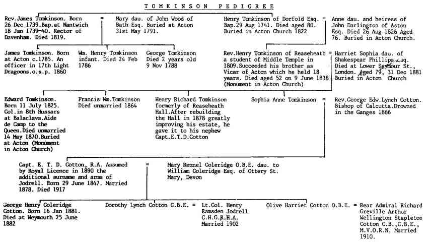
The above Tomkinson Pedigree shows the various members of the Tomkinson family who lived at Reaseheath with the exception of Henry Tomkinson (who bought the hall) and his wife, and the 2 husbands of the Cotton-Jodrell girls. It is interesting that the sons of the family either entered the church or joined the army.
Sir Edward Cotton-Jodrell
|
|
Sir Edward Thomas Davenant Cotton - Jodrell K.C.B., J.P. and D.L., owned estates at Yeardsley in Cheshire and Shallcross in Derbyshire. He commanded the Cheshire R. Engineers from 1888 to 1908, was on H.Q. Staff at the War Office from 1906 to 1912 and retired as Colonel in the Territorial Force. He was an M.P. for the Wirral division of Co. Chester from 1885 to 1900. He assumed by Royal licence in 1890, the additional surname and arms of Jodrell. |
The great window in the hall at Reaseheath contains various coats of arms in stained glass which show the historical connections between the Cotton and Jodrell families culminating in the centre with the Cotton-Jodrell coat of arms. Sir Edward presumably commissioned a local glazier to produce this masterpiece some time after 1890.
It was evident that Sir Edward Cotton-Jodrell was keenly interested in agricultural education in Cheshire and it is fitting that the estate was eventually bought by the Cheshire County Council in 1919 to establish a School of Agriculture.
The Tithe Map Of Worleston 1842
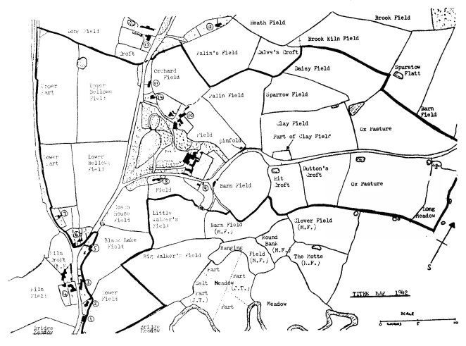
Many people are surprised to learn that tithes were still being paid in the 19th Century. In fact a detailed survey was carried out throughout the whole of Britain of all land and property resulting in the tithe maps of 1840 to 1842. No survey as detailed had been carried out since Domesday and the object of the survey was to result in the abolition of the payment of tithes. Tithes at that time were payable part to the local vicar and part to the landowner.
On examining the Tithe Map, the Estate boundary can be easily seen. Dwellings on and around the Estate are numbered, the occupants names being listed with the map. Note that dwellings 1, 3, 5, 8, 9, 11 and 14 are no longer in existence.
Stephen Hollowood (see earlier) lived in dwelling No.3. There were a total of 4 families living in this building. A village pump was located nearby (see 1919 Map).
Fields within the Estate boundary were the property of Harriet Sophia Tomkinson. Those outside the Estate with no initials in brackets belonged to Francis Elcocke Massie of Poole Hall.
M.F. is Mary Furber who owned Home Farm (4).
J.H. is James Walthall Hammond (of Wistaston Hall).
J.T. is Juila Tomkinson (sister-in-law? to Harriet Sophia).
Some of the field names are intriguing. The Motte field or moat field obviously refers to the mediaeval earthwork. Hanging field may refer to its position as it is "hanging" between road and river, i.e. it is not bordered by either. Some are named after a person, e.g. Dutton, Spurstow, Palin, but who were little and big Walker? There is evidence of brick manufacture in Kiln Field, Kiln Croft and Brook Kiln Field. Other names are self explanatory.
Reaseheath Estate Map 1919
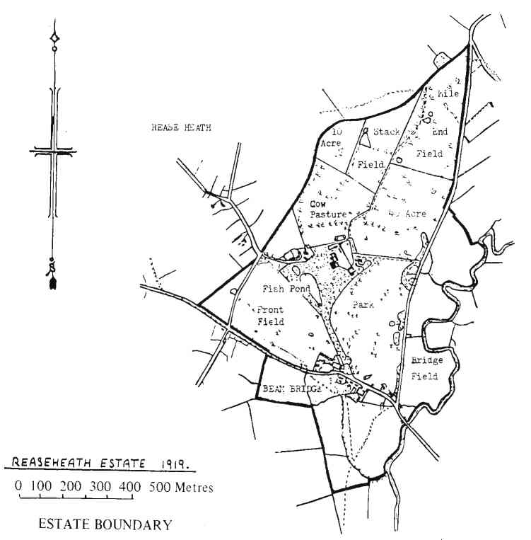
The first thing that strikes the eye, on looking at the attached map is the fact that the fields within the Estate are much larger than the ones shown on the 1842 tithe map. Trees are included on the map and show the exact position of each individual tree. Note that Rease Heath village is marked on the map, North of the Estate, and Beam Bridge hamlet to the South, within the Estate boundary. Old photographs of the back drive confirm a fence on its Northern side and the trackway open to the field on its Southern side, hence the broken line. A boat house is marked on the edge of the lake (fish pond!) and the trial ground may be a circular course for training horses. in the S.E. corner or Cow pasture. The row of broken dots near the Southern edge of the Estate show the line of the civil parish boundary.
Reaseheath Hall
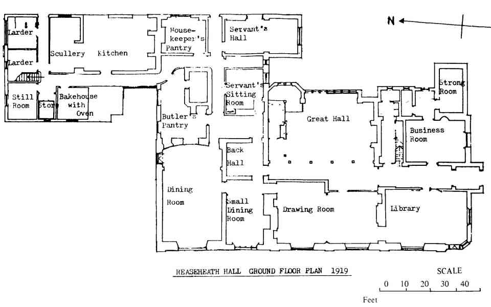
The present building known as Reaseheath Hall would appear to have originally been built some time about the mid l8th Century. There is evidence of half timbering i.e. wooden vertical and horizontal beams with ordinary brickwork between, on an external wall of the upper floor which suggests an original wall. This would support the theory that the building was probably in the shape of an "L", the great hall being added at a later date. Certainly examination of the external wall of the great window by the cellar entrance would support this view.
The half timbered section is immediately above the supporting pillars in the great hall and the original front door could have been situated somewhere along this line or across the inner corner of the "L" immediately under the grand staircase. It was characteristic of all old houses to have their front door situated in the middle of the building and not at the end as it now is at Reaseheath.
The great hall is an attractive sight and it may have been added to the original building in 1875. There was a great revival of interest by the Victorians in mediaeval history, particularly the associations with the age of chivalry. This resulted in the building of great halls in many large houses which were meant to resemble the mediaeval banqueting hall.
At one end of the great hall is the fireplace which was obviously meant to be a major focal point. The Cotton-Jodrell coat of arms was added above the fireplace at a later date. The minstrel's gallery is of sufficient size to hold 3 instrumentalists, which is the number that one would expect in the mediaeval house.
The grand staircase at the other end of the great hall would be used at dances and parties when the visitors, particularly the ladies, would make a grand entrance down the stairs to the assembled guests below. The relief in plaster above the staircase depicts a music and dance theme which further suggests the purpose of the hall.
The grandfather clock on the staircase has the name John Starlyer, Nantwich, written on the brass clock face. The clock mechanism was made at Clerkenwell in London 200 years ago. This would have been assembled at Nantwich by John Stanyer in the wooden case which he made for it. The clock has only been working for about 70 years.
The shields referred to earlier, in the great window, were actually inserted into the glass at a later date than the original window. If one examines the glass closely, it can be seen that a different and more modern grass has been used, The Jodrell coat of arms on the left-hand side of the window is that borne by the earliest recorded member of the family, William Jodrell of Yeardsley who served as an archer under Edward the Black Prince. The Cotton coat of arms is depicted in the three hanks of cotton. The date above each shield refers to the year in which a member of the family was married, with the husband's coat of arms to the left, and that of the wife to the right.
The external fabric of the building was given an outer coating of very attractive red brick about 100 years ago and this is particularly noticeable along the front and side facing the lake. This accounts for the extreme wall thickness which is apparent in certain parts of the building. If one walks around the side away from the lake, a change to the older brickwork can be seen, and also what may be two original chimneys above the fireplace in the present Principal’s Office. All other chimneys were built in the tall Jacobean style with the red brick mentioned earlier.
A ground floor plan of the Hall is enclosed showing the function of each room before it was purchased by the Cheshire County Council in 1919. The dining room is worthy of mention as being a particularly fine example of Victorian interior decoration. Note the two doors for entry and exit of the food. The butler's pantry was situated both to keep the kitchen smells away from the dining room and for the butler to keep an eye on the front door so that as soon as carriages arrived, the doors would be opened ready for the waiting guests. The back hall was almost certainly Ian existing hall and stairway. The still room was a small room used for producing still waters and also delicacies for the table by the lady of the house, or more likely, the housekeeper.
The cellars were built with an extremely large number of bricks. These were obviously manufactured locally and the Tithe Map of 1842 would confirm this fact. There is a shallow well in the cellars which was probably at one time the only water source for the house. Food would be stored in the cellars and there is ample storage space for wine and spirits with some wine racks still being in their original positions. There appears to be plenty of storage facilities for bottles in an upright position suggesting that a lot of port would be consumed here. Large wooden doors with heavy bolts and hinges separate parts of the cellars. Some have metal locks encased in wood which would indicate that they are probably about 200 years old.
The Cheshire College of AgricultureOrganised agricultural education was introduced in Cheshire in 1890 with the formation of an Agricultural Instruction Committee comprised of forward-looking landowners and farmers. This committee appointed at their own expense, a peripatetic instructor and founded a teaching centre on a dairy farm at Worleston. This establishment became known as the Worleston Dairy Institute and played a leading part in Agricultural Education in the County. It became increasingly clear by 1914 that it could no longer meet the demand. Meanwhile, a College of Agriculture had been established at Holmes Chapel in 1895 and this was affiliated to Manchester University. It was felt that one centre should be found to accommodate all agricultural education in Cheshire. Henhull Hall was purchased in 1914 to provide a more adequate Dairy Institute, but plans were held up due to war conditions. In 1919, the adjacent Reaseheath Hall came on the market and with the aid of a Government grant, the beautiful Estate of Reaseheath was purchased by the County Council. Holmes Chapel was taken over by the Home Office as an industrial school and the staff in the poultry and dairy departments transferred to advisory work in the County.
Reaseheath Hall was utilised as a men's hostel and as the administrative headquarters of the School of Agriculture, adjacent buildings were adapted as lecture rooms and laboratories. The farms were stocked, the gardens extended, a poultry department created and the School opened to men students in 1921. A new hostel for women students, a dairy department, and new farm buildings were erected and officially opened in 1926 by the Duke of Windsor, then Prince of Wales.
"It was a very cold day and he arrived in an open car from Chester, frozen and consequently in a ruffled and bad temper. Added to that, cream had been provided for the royal tea and when milk was preferred there was such a melee because none could be found and the cream had to be watered. Rumour had it that Miss Wallis, the Matron and hostess, kept the Prince's cup unwashed for years. As Miss Forster (head of Worleston Dairy Institute) on an earlier occasion kept the chairs the King (George V) and the Queen had sat on, inviolate!"
The above quotation from personal recollections of Mrs. Katharine Alice Young (daughter of W.B. Mercer, former Principal).
Henhull Hall was sold in 1924 and certain equipment from Worleston Dairy Institute in 1925 followed by closure of the Institute in 1926.
An early prospectus of the School (between 1921 and 1926) required that students provide themselves with dairy aprons, pyjama cases, linen bags, boot brushes and blacking, strong boots and clothes for practical work on the farm.
Certificate courses in agriculture, dairying, poultry husbandry and horticulture were provided from 1921 to 1939. The School also was required during this time to provide an advisory service to the agricultural industry.
The outbreak of war in 1939 interrupted normal education and the school used for training recruits in the Women's Land Army. By February, 1943, over one thousand girls had successfully completed their courses; an achievement which earned royal commendation for Cheshire. In addition, during the wartime period, part of the education block was occupied by the staff of the War Agricultural Executive Committee and the National Milk Testing and Advisory Service. After the war years, normal courses were gradually revived, first in shortened form, until by October, 1947 it was possible to return to the full range of one year Certificate coursework. The National Agricultural Advisory Service was established in 1946 and from that time, the College no longer carried direct responsibility for advisory work to the farming community.
Further land was purchased in 1956 with the addition to the estate of Reaseheath Old Hall and its accompanying fields. The final addition to the estate being the rental of Cobbs Lane Farm and its fields from the ancient Beam Heath Trust (see Antiquities Map).
Changes at the School/College since the Second World War include:
The School of Agriculture became a College in November 1967, and it now offers a wide range of courses in agriculture and allied subjects to students from the county and beyond its borders.
Reaseheath Quiz
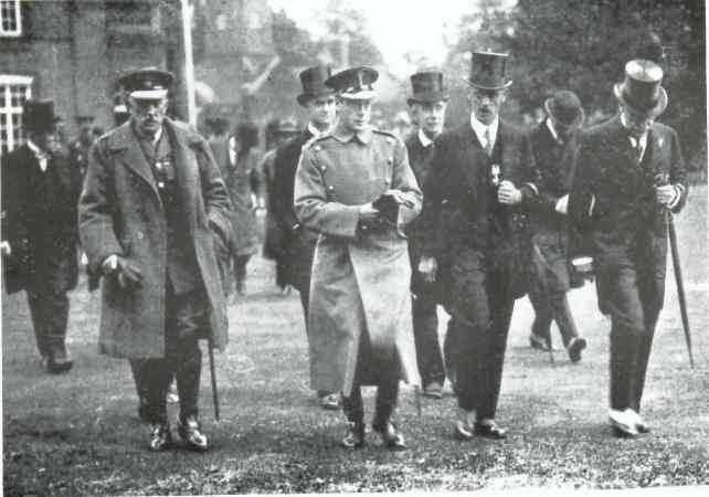
The Prince of Wales about to open the women’s hostel, dairy and new farm buildings October 1926
The Reaseheath College Trust
The Trust has been established to provide funds for the improvement of facilities at the College, and to assist students of the College who may be suffering severe financial hardship.
In addition to providing funds to improve facilities at the College to benefit the whole of agriculture and its ancillary interests in Cheshire, the Trust will have powers to provide and maintain a resource and information centre for use by the agricultural community in Cheshire. Also it will provide funds to enable the College to promote and undertake experimental work, to make grants to students and to contribute towards the cost of educational travel. Finally it will enable the College to maintain and extend links with other similar establishments both in the United Kingdom and overseas.
The Trust is a registered charity and is funded entirely by voluntary donations made by individual farmers, industry, agricultural and related organisations in horticulture, food and dairy processing and agricultural engineering. Anyone interested in the work of the College and the advancement of agriculture and its related subjects is invited to contribute.
Further details can be obtained from the College.
Milestones in Reaseheath History
|
Year |
Event |
|
1538 |
Land at Rees Heath, bought by Roger Chetwood and Ralph Wilbraham. |
|
1580 |
Richard Wilbraham living at Rees Heath. |
|
1624 |
Cheese made at Rees Heath. |
|
1772 |
Reaseheath Hall sold by Windsor family to Henry Tomkinson. |
|
1777 |
Reaseheath Old Hall shown on Burdett's map of Cheshire. |
|
1878 |
Building alterations to Hall, Estate given to Captain E. T .D. Cotton (later Colonel Sir Edward Cotton-Jodrell). |
|
1919 |
Purchase of Estate by Cheshire County Council. |
|
1921 |
Official opening of the Cheshire School of Agriculture by Sir Arthur Griffiths Boscowen, Minister of Agriculture. |
|
1926 |
H.R.H. The Prince of Wales.(later Duke of Windsor) opens the Women's Hostel, Dairy and Farm buildings. |
|
1982 |
H.R.H. Princess Anne opens the new Food/Dairy buildings and Tetrapak Training Centre. |
Editors footnote
Since this booklet was written there have been many changes to Reaseheath College.
Do you have any interesting memories, or old pictures, of Reaseheath? If you do, I'd be interested to hear from you. Please e-mail me wjpearson@gmail.com
Bill Pearson
Click here to find out more about the Roman Road at Reaseheath.
Click here to find out more about the Worleston Dairy Institute.
Click here to go to Bill Pearson's home page.